Sherwood Road Level Crossing: Long Downtimes Add to Brisbane West Traffic Congestion

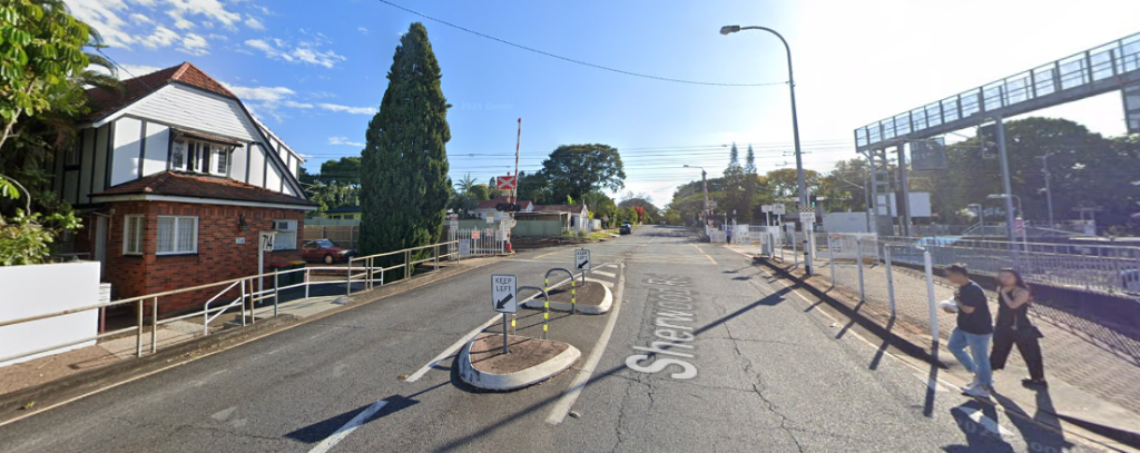
Commuters and local drivers in Sherwood are frequently facing long waits at the level crossing on Sherwood Road. Extended boom gate closures during weekday mornings are contributing to congestion on local roads, with queues sometimes stretching into nearby streets and affecting travel across the suburb.


Read: Push to Reopen Tennyson Rail Line Ahead of Brisbane 2032 Olympics


Recent Queensland Rail data shows Sherwood Road’s level crossing recorded an average closure of 1 hour and 44 minutes between 5 am and 10 am on weekdays, making it the second-longest downtime of the 50 crossings monitored in south-east Queensland. Across the network, 26 crossings were closed for more than an hour on average during the morning peak, up from 13 in 2022. This reflects a broader trend of increasing train frequency and longer dwell times on the rail network.

Photo credit: Google Street View

The long closures affect not just motorists but also local traffic patterns. Peak hour delays at the boom gates can cause queues along Sherwood Road and on feeder streets, while local buses may also experience hold-ups. Residents have noted the effect on daily routines, including the timing of commutes and access to services.

Queensland Rail attributes these longer closures to a combination of factors. More trains are now operating on the suburban network, including additional passenger services and freight, while station dwell times have increased due to growing patronage and accessibility support. These operational factors extend the duration the boom gates remain lowered.

Photo credit: Google Street View

Experts in transport and urban planning note that extended level crossing downtimes can worsen traffic congestion in surrounding areas. When gates remain down for a significant portion of peak periods, the delays affect not only motorists but also pedestrians, cyclists, and local public transport services.

Queensland has identified 13 level crossings across south-east Queensland for removal or upgrades to improve safety and reduce congestion. While it is not confirmed whether Sherwood Road is included in these short-term projects, the wider initiative aims to address the cumulative effects of frequent and prolonged boom gate closures on local communities.


Read: Residents Say Oxley & Inala Car Parks Among Brisbane’s Most Stressful


Until upgrades or removals occur, commuters using Sherwood Road are encouraged to allow extra travel time, plan alternate routes where possible, and factor in potential delays caused by peak hour train crossings. The intersection of local roads and rail infrastructure remains a persistent source of congestion in the western suburbs of Brisbane.

Published 24-October-2025

Police Seek Public Assistance For Attempted Arson in Sherwood

Police are seeking public assistance following an attempted arson at a cosmetic business on Sherwood Road on 6 December 2024.


According to the official police appeal, two men driving a silver Volkswagen Golf R with stolen plates 470BQ4 stopped at the business around 5:00 AM. One suspect broke the business window with a brick and attempted to light a Molotov cocktail.

The suspects left the scene after seeing a person approaching on a bicycle.

Suspect descriptions:

  • First suspect: High-vis jacket, black pants, grey sneakers
  • Second suspect: Black pants, black long-sleeve shirt

Police are requesting CCTV, dashcam, or other information to assist their investigation.


If you have information for police, contact Policelink by providing information using the online suspicious activity form 24hrs per day at www.police.qld.gov.au/reporting.

Report crime information anonymously via Crime Stoppers. Call 1800 333 000 or report online at www.crimestoppersqld.com.au.

Quote this reference number: QP2402093419

Published 6-December-2024

New Solar-Powered Flood Warning Signs to be Installed along Roads Near Oxley Creek

Photo Credit: Facebook/Dejan Subaric

More solar-powered, automated flood warning signs will be installed across Brisbane, including two roads along Oxley Creek, to lessen the risk of motorists driving through the flood waters.


On top of the 10 existing automatic flood warning signs found in Bardon, Moorooka, and Kenmore Hills, 12 more will be rolled out in the coming weeks. These locations were picked based on the advice of flood and traffic experts.

The new sites are located at the following locations:

  • Paradise Road, Willawong / Larapinta (Oxley Creek)
  • Sherwood Road, Rocklea (Oxley Creek)
  • Lancing Street, Pullenvale (Pullen Creek)
  • Bowhill Road, Durack (Hanleys Creek)
  • Kholo Bridge, Kholo (Brisbane River)
  • Rafting Ground Road, Brookfield (Moggill Creek)
  • Victoria Street, Newmarket (Enoggera Creek)
  • Formosa Road, Belmont
  • Grandview Road, Pullenvale (Pullen Creek)
  • Gap Creek Road, Kenmore Hills (Gap Creek)
  • Bracken Ridge Road, Bracken Ridge (Bald Hills Creek)
  • Wynnum Road, Tingalpa (Bulimba Creek)

“Too many motorists drive through flooded roads, putting their lives and the lives of others at risk, and these signs automatically turn on once a creek or waterway reaches a certain level,” Mr Schrinner said.

Flood Warning Signs
Photo Credit: Facebook/Adrian Schrinner

The new signs are backed by LED lights so they will remain highly visible for motorists, especially in the evening.

The Federal Government allocated $99,000 for this project whilst Brisbane City Council has invested $500,000 so far and will be installing more signs before the year ends.

Priority has been given to sites where there are records and histories of motorists driving through the water despite the “If it’s flooded, forget it!” campaign;

The mayor said that this investment in new automated technology is a “great step forward.”

“Unlike 2011, the record-breaking rainfall in February caused a combination of river, creek, and overland flow flooding right across Brisbane.”


“This made it unsafe and impossible for Council officers to get to some areas and erect temporary road closed signs.

“By using this automated sign technology, we will be able to close and actively monitor flooded roads.”